
One of the most important environmental issues associated with contemporary openpit mining is the closure of mine pit lakes and the perpetual legacy these lakes can potentially generate. Ideally, successful pit lake closure includes the following:
The water quality within the pit lake, plus surface water and ground water discharging from the pit lake, meets premining or other acceptable water quality conditions of the receiving environment.
- The termination of all active treatment processes
- The return of the pit lake to the government for long-term care and maintenance
- The release of the mining company from all future liabilities associated with the pit lake
- The return of the environmental bond to the mining company
- The reuse of the pit lake for some post-closure, beneficial purpose
The achievement of these goals is known as walk away pit lake closure. Peer-reviewed publications of successful walk away pit lake closure provide mining companies with the ability to address public concerns regarding the safety of pit lakes that commonly occur during the permitting, operations, and closure phases of mining. To date, most published work on walk away pit lake closure work has occurred in the coal mining sector in Germany and Australia (McCullough et al., 2009; Jones and McCullough, 2011; Kumar et al., 2013; Schultz et al., 2013). In North America, examples of walk away pit lake closure are not widely discussed in the literature despite there being excellent examples from the coal mining sector in Alberta, Canada (e.g. Pleasure Island, Black Diamond, East Pit, Sphynx, Robb, Lovette, Siltstone, and Sterling), and from the iron mining sector in Minnesota in the US (e.g. Portsmouth Lake, see MNDNR, 2018). Although seldom included in discussions of pit lakes from the metal and coal mining sectors, the aggregate and fabricated-stone mining sectors also produce pit lakes, and there are numerous examples throughout North America where these pit lakes have been successfully closed and transformed into post-mining resources (Vandenberg, 2018; Crossman, 2019). The difficulty of finding these good examples in the literature makes it challenging for companies to respond to public and regulatory questions regarding pit lake closure and reuse. As such, there is a pressing need to document the motivations and approaches used in examples of successful, walk away pit lake closure in North America so that the mining industry, at large, can learn from these examples and can better address public concerns.
This article from Mining Engineering provides a first-person account by Gerry Stephenson, who was chief mining engineer of Canmore Mines and was instrumental in the planning and reclamation of Canmore Creek Mine pit lakes into sustainable, post-closure resources, which are highly valued today by the local community and tourists. If proposed today, mining activities in this area—Canmore, Alberta, Canada, immediately south of Banff National Park—would likely generate intense public scrutiny. The purpose of this article is to raise awareness of an outstanding example of mine pit lake closure and reuse and to highlight the vision, planning and decades-long effort that led to this success.
Site Description and History
Mining of semi-anthracite coal in the Bow River valley near Canmore, Alberta, began in 1886. Nine different coal seams were mined by underground methods until the Canmore Mines closed down in 1979. The operations were always extremely complex with gradients between 15° and 90°, very complicated geology and methane emissions up to 2,300 cu ft/st of coal produced. In 1966, the company opened several small openpits to boost production for the Japanese market. Extreme faulting and folding of seams created opportunities for pits with economic stripping ratios, though gradients up to 90° limited the depth of openpit mining to 37 m.
Stephenson arrived from Northern England in 1968 where he had observed some remarkable reclamation of land seriously damaged by coal mining going back to the early years of the industrial revolution. He took over as the company’s chief mining engineer and found a small, but efficient, surface mining operation with several small pits exhausted and two operating. The openpits, Canmore Creek Numbers One and Two, were extracting 3.6-m thick seams dipping at 80°. At this time, 1968 to 1974, there were few regulatory, public, or corporate requirements for reclamation. Obtaining a permit for opening a surface or underground mine was not difficult. Bureaucrats with provincial energy, lands and forests, environment, and water departments were relatively new to their respective fields. There were no hard and fast provincial mine reclamation standards, water quality standards for mined lands, or monitoring requirements. From a public perspective, Canmore had been a mining town for 90 years, and the whole of the population depended directly or indirectly on mining. There was a huge area of undisturbed land, rivers, lakes, and streams surrounding the mine. As such, there was very little thought given to the damage being done by coal mining. Likewise, the company had no policy on reclamation partly because, at that time, surface mining had recently started and the problems were not seen to be very serious.
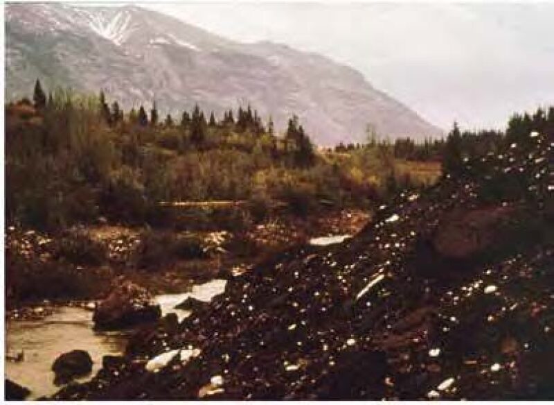
with mine waste covering the stream bank.
Consequently, the mines were not a pretty site. No separation of overburden had been attempted so, spoil heaps contained a mixture of soil, gravel, rock, and coal waste, spiced up with wire rope and spilled oil. Although water quality was not analyzed in a laboratory before, during, or after mining, water pollution was evident based on qualitative, visual inspection of turbidity and aquatic life. Overburden was being dumped over the bank of Canmore Creek where vegetation had been destroyed, heavy siltation had occurred, and the cutthroat trout had disappeared as had all insect life (Fig. 1). No reclamation had been attempted and the mining plans had omitted any procedures to facilitate remedial work. This was accepted practice in the Rocky Mountains of Alberta at the time, where coal was being mined at elevations up to 1,370 m, with temperatures down to −31°C in winter and very short summers. Locals described the climate as 7 months of winter and 5 months of poor skiing.
The Canmore mines were operating adjacent to Banff National Park, and wildlife was abundant, with bighorn sheep using abandoned highwalls for refuge and as salt licks. Deer and elk were numerous, and predators included cougars, wolves, wolverines, and black and grizzly bears. It was clear that, unless steps were taken to develop and apply methods of reclamation designed for the climate and the landscape, with serious consideration given to the impact on wildlife, applications for future mine permits were not going to be enthusiastically received by the provincial government. The future of the company was tenuous.
Creek Bank Stabilization and Revegetation
Clearly, the priority was to clean up the mess caused by past mining. The first task was to rehabilitate the bank of Canmore Creek. This would provide an opportunity to experiment with a variety of procedures for stabilizing spoil, finding soil, formulating appropriate seed mixtures, and seasonal timing. The mine waste was lying at the natural angle of repose, about 40°, and stabilization without further damage to the creek was needed. Backhoes were used to create terraces on the 12-m-high pile, but, of course, there was no soil. However, peat and silt were available and were mixed 50/50, the silt providing weight and the peat, moisture retention. This mixture was poured down the terraced bank covering 80% of the slope with 15 to 25 cm of soil. Hydro seeding with seed, water, and fertilizer went ahead using various seed mixtures. Each mixture contained native seeds, which included:
- Grasses with a short life capable of rooting quickly to stabilize the soil
- Grasses with a long life capable of selfseeding
- Legumes such as clover
following bank stabilization and revegetation.
A proven system of mulching was employed using a mixture of chopped straw and a small amount of asphalt to bind the straw together. A layer of mulch approximately 10 cm thick was laid down creating a microclimate over the seeded soil below. The creek bank was completed in 1970 and, within 2 years, there was a healthy crop of grasses up to 30 cm high covering the riverbank (Fig. 2). The soil layer and the vegetation held firm over most of the bank. This experiment, the first attempt at remediation of an industrial site in the area, had been successful. A great deal had been learned which could be applied to the subsequent reclamation of openpit mine sites.
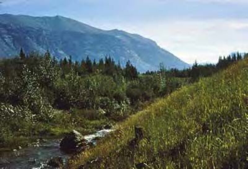
Since this work was done, the bank has been completely rehabilitated by nature with native shrubs and 9-m-high trees growing on the original soil and the weathered rock (Fig. 3). The stream runs clear, and trout and invertebrates have returned.
The triangular boulder in the stream
is the same boulder shown in Figs. 1 and 2.
Reclamation of Canmore Creek Mines Numbers 1 and 2
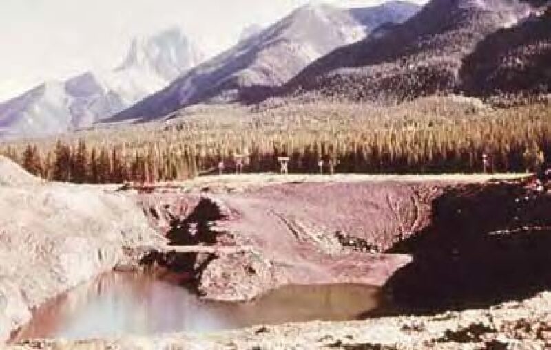
These two openpits were completed in 1972 but without any plans for reclamation. There were two parallel pits, each about 37 m deep with spoil piles of gravel, soil, and rock mixed together along both sides of the two pits, plus a spoil pile extending down and into the creek at the west end. The area affected by mining was approximately 610×365 m—not a large area but one with plenty of problems. There was a small, spring-fed stream discharging into the area from the east end. Approximately 60% of the waste was bulldozed back into the openpits (Fig. 4), with an attempt being made to keep gravel for use during contouring. The waste remaining in the spoil pile was contoured to create stable slopes.
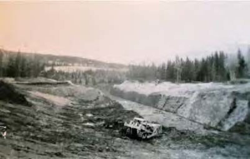
during backfilling in 1972.
A small dam was built across the area which it was hoped would form a pond with an area of 1.2 ha and a depth of 3 m. This was very successful. An area of approximately 1.6 ha between the pond and Canmore Creek was covered with gravel, which filtered the overflow from the pond to remove silt before the water entered the rehabilitated Canmore Creek (Fig. 5). The revegetation of the area was carried out in similar fashion to the creek bank with some modifications based on the previous experiment at that location. For example, it was important to hydroseed and mulch late in the year before winter arrived. This encouraged seed to germinate in spring when the air warmed up and the snow melted.
after backfilling in 1972.
Within 2 years, there was a healthy vegetative cover of grasses and legumes as well as some small transplanted trees (Fig. 6). The pond quickly became a home for brook trout and salamanders, hence the new name, Salamander Pond. Today, it is difficult to see any scars left by mining. The 1.2-m tall trees that were planted are now 9-m tall, while Salamander Pond looks absolutely natural.
after reclamation in 1974, renamed Salamander Pond.
Development and Operation of Canmore Creek Mine Number 3
In 1972, a new openpit began producing coal in an area where the folding of seams 3 to 3.6 m in thickness had resulted in doubling of the coal thickness on anticlinal and synclinal folds with seams dipping at up to 70°. The openpit was designed for a depth of 37 m at a low stripping ratio. For the first time, a new pit was planned with the benefit of experience in the rehabilitation and revegetation of mined land (Stephenson, 1974) and, equally important, the capability to include measures that would facilitate the rehabilitation process as part of the mining operation. These included:
- Excavating the soil, gravel and rock separately
- Placing these materials in locations convenient for creating a new landscape
- Incorporating springfed streams into the finished landscape, and creating a lake
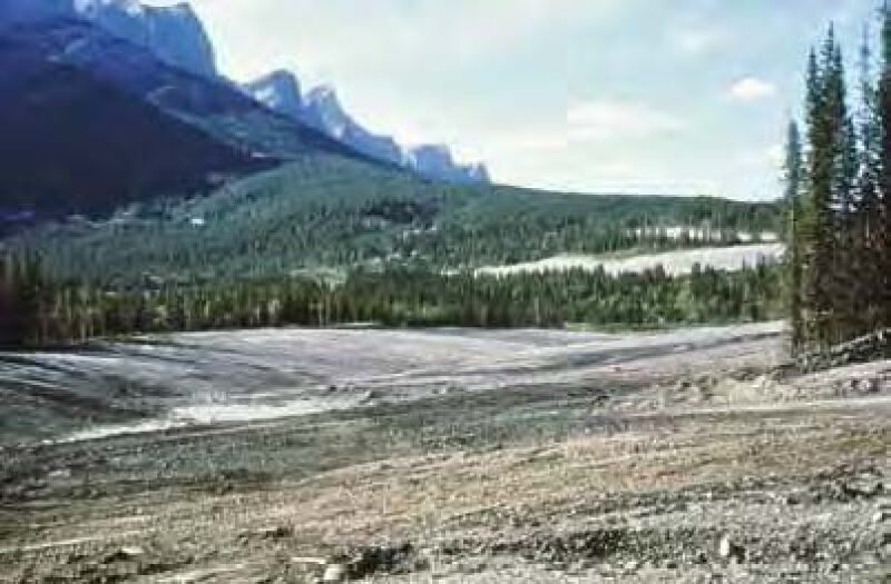
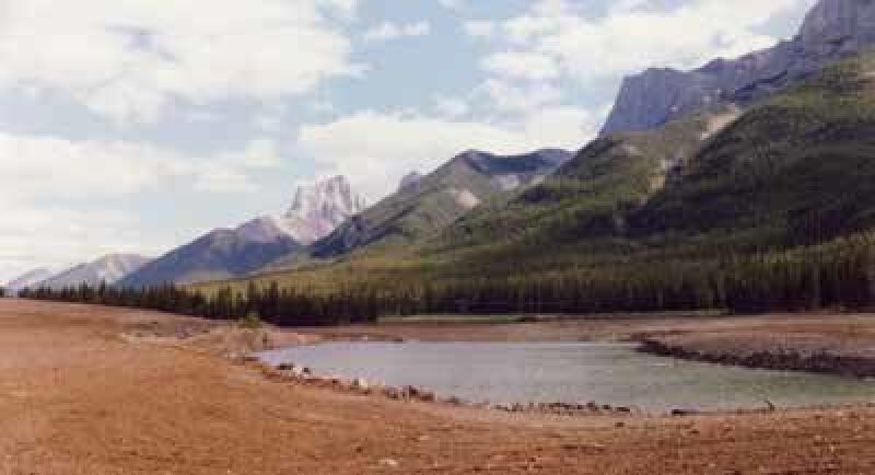
Coal extraction was completed in early 1973 and created a rectangular pit 365 m long, 150 m wide, and 36 m deep (Fig. 7). The perimeter had almost vertical cliffs along the two longer sides with slopes of 20° to 30° elsewhere. A gravel bed extended up the lower slopes of the 2,743-m high mountain range alongside the pit to an elevation of 1,980 m where the thickness of gravel was 31 m or more. Every spring, melting ice and snow from the mountainside fed a large aquifer in the gravel. This aquifer, in turn, discharged clear water into the openpit at the interface of the bedrock and the gravel throughout the year, even in the middle of winter.
after mining in 1973.
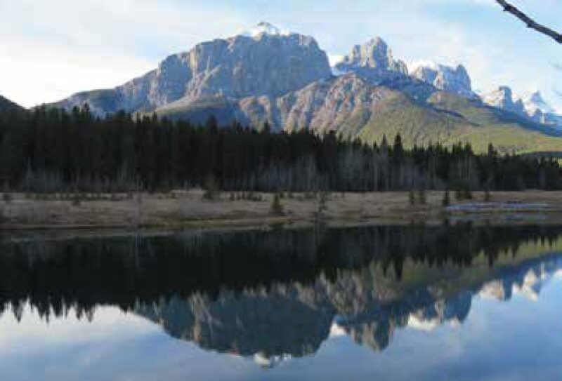
During mining, this water had been a problem. In closure, it became an asset valued for its quality and uniform flow, for here was the essential element that would allow the development of a water body in the openpit excavation which might, someday, be worthy of being called a lake. And, with the 2,743-m-high Three Sisters Peaks towering over the area, this lake could become a very special place.
The Creation of Quarry Lake
In 1974, some of the rock began to be moved from the spoil piles back into parts of the excavation. Water from the gravel beds had filled the excavation to a depth of about 6 m. However, the level of the water would go no higher because the old haul road, which allowed coal to be trucked from the bottom of the pit, created an overflow point that limited the depth to 6 m and the size of the water body to about 0.8 ha surrounded by highwalls 15 to18 m high. This was a small water body, but not, by any stretch of the imagination, a lake. To achieve this, the overflow point needed to be raised. Locating some material with a high clay content, a dam was created in the overflow location at the same elevation as the point where water from the gravel aquifer entered the water body.
At this point, the province of Alberta took back control of an area of more than 80 ha. This included the mined and reclaimed land described earlier together with the land that encompassed the Canmore Creek Number 3 Mine that had been partially reclaimed. This acquisition was part of a strategy by the ruling Conservative Party, led by Premier Peter Lougheed, to develop Alberta’s mountainous areas, and required far less regulatory sign off than by today’s standards.
Meanwhile, Stephenson had left his position with Canmore Mines and, with his long-suffering wife Avice, formed a consulting company based in Canmore. The provincial government engaged him to design the completion of reclamation and rehabilitation of the area. Importantly, they encouraged Stephenson to continue with the development of a waterbody, hopefully a lake. A new reclamation plan was prepared that included:
- Completion of backfilling rock into the excavation designed to leave 40% of the perimeter as steep cliffs adjacent to water 6 m deep
- Reduction of the maximum lake depth to 24 m
- Two shallow beach areas, one at each end of the water body
- Retention of material in the existing spoil heaps to create gently sloping features 9 m high surrounding the water body
- Spreading of gravel and soil from the storage areas on the area affected by mining
- Hydroseeding and mulching using techniques proven by previous experience
after mining in 1974.
The inflow from the gravel bed aquifer, as anticipated, caused the water level to rise to the perimeter of the pit. The dam successfully blocked the outflow, and, 2 years later, there was a water body 24 m deep and 4 ha in area surrounded by gently sloping hills (Fig. 8). Still there was not a lake. The water was heavily silted from exposed coal and rock in the bottom of the pit. Methane gas from the exposed coal seams at the bottom of the pit was bubbling to the surface, and floating debris, mostly logs and roots, covered much of the surface. It was expected that the silt would settle over time and that the coal seam would drain of gas very quickly as the coal was very gassy but very permeable. Still, some brave souls, Stephenson not being one of them, began swimming in the bitingly cold water undeterred by the floating logs and the methane gas. Fortunately, over the next 2 years, the silt settled, and the water became clear enough to give 1 m of visibility (Fig. 9). The coal seams became depleted of methane, and the bubbles stopped forming after 2 years, while the debris was cleared from the surface, much of it by local volunteers. No water-quality monitoring was performed over this period other than qualitative visual inspections of turbidity, gas bubbles, and the development of fish populations.
after recontouring the land surface in 1976
and creating the water body.
Continued Restoration: A Community Effort
Public interest in reclamation had begun during the correction of the problems caused by mining. Once the population began to see that land could be reclaimed to enhance recreational opportunities and wildlife habitat, they came onboard as did the mine’s owners. By the late 1970s, although there was still no lake, the gradual improvement in conditions created optimism. Sand was brought in for the beaches and miners helped to clean up the surroundings, put in oil drums for garbage, and built picnic tables (Fig. 10). The lake had been stocked by Alberta Fish and Wildlife with small rainbow trout, which did not work out well as most of them finished up in local cooking pots. A later planting of arctic grayling worked well, as these fish can thrive and breed in the lake (Fig. 11). Today, no more stocking is necessary, and the eggs are collected and added to three other Alberta lakes (Stelfox et al., 2005).
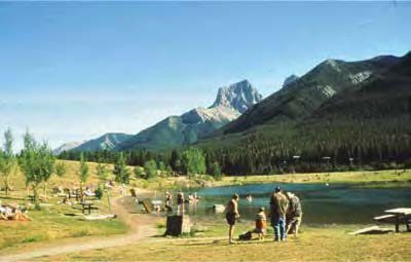
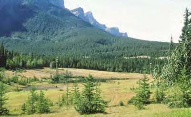
was renamed Quarry Lake in 1982
following reclamation.
showing the surrounding forested landscape
and adjacent neighborhood.
At this time, the chairman, Walter Trost, and vice chairman, Stuart Smith, of Alberta’s Environment Conservation Authority, visited the site. They were very impressed, stating that the work being done in Canmore was the best they had seen in Western Canada. The 1988 Winter Olympics were centered in Calgary and the Nordic events were held at Canmore, with many of the trails built on areas that had been mined and reclaimed. Visitors began to arrive, and the Town of Canmore began to develop a picnic area at the lake with toilets, more trees, and enhancement of the beach area. A hiking trail was established around the lake and connected to the Canmore trail system with more than 40 km of trails for hiking and cycling.
In 1999, Hollywood came to Canmore to make Mystery Alaska, a film about a small-town hockey team taking on the New York Rangers of the National Hockey League, starring Russell Crowe and Burt Reynolds. Consulted about filming the hockey game on Quarry Lake, Stephenson suggested that the fractured lake ice might create more of an action movie than they expected. The game was filmed on a different lake nearby, but no Oscars were awarded.
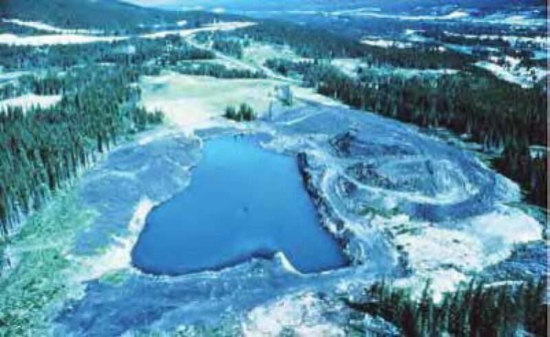
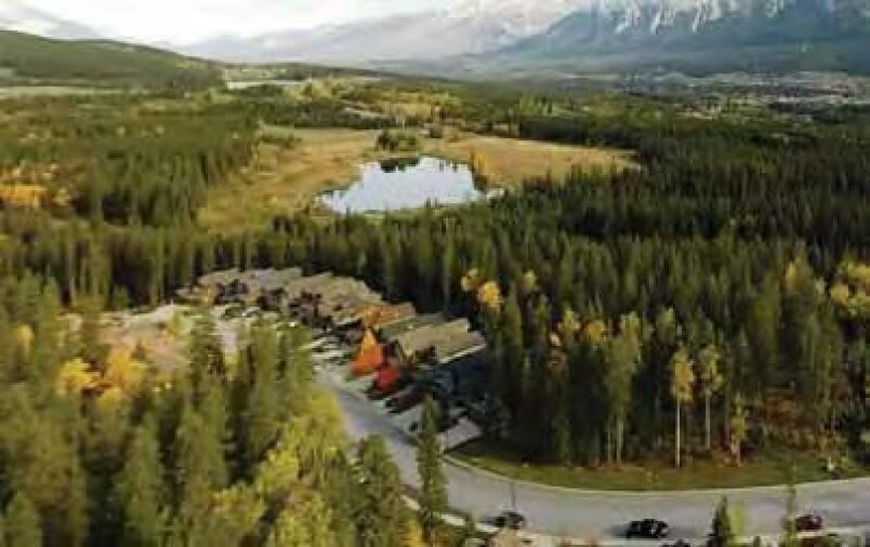
In 2002, a major step was taken when the Rocky Mountain Heritage Foundation and the Town of Canmore joined together to obtain 96 ha from the Crown (i.e., the Province of Alberta) for the sum of $1 (Canadian) to form Quarry Lake Park. The land included the area surrounding Quarry Lake, Salamander Pond, Canmore Creek, reclaimed land from several other smaller openpits, and thickly forested areas that had not been affected by mining (Fig. 12). In fact, almost two thirds of the park is forest. In many areas, stands of mature trees had been left to screen the mining operations and to provide shelter for ungulates from predators. This combination of grassland and forest works well as the revegetated areas continue to attract herbivores. Thanks to funds provided by the foundation, chaired by Stan Milner, and by Canmore taxpayers, the facilities have been greatly improved while still retaining a natural look that was an essential part of the design for the lake. In fact, many first-time visitors are amazed when they see the photos of mining operations in the 1970s (Figs. 1 and 4) and find that the lake they now enjoy was once an ugly openpit (Fig. 7). The whole park now forms a very attractive location for outdoor activities with Quarry Lake its centerpiece.
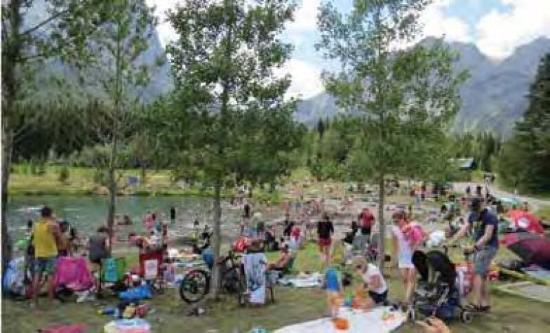
Today, the lake is a hive of activity, especially on summer weekends, with as many as 400 people on the shores of the lake and on the trails running through the park (Fig. 13). Every type of unpowered watercraft imaginable is on the lake from inflatable mattresses to canoes, kayaks, and paddle boards. Other facilities included in the park are an area for exercising dogs off leash and two car parks with space for 150 vehicles. The popular tourism website TripAdvisor rates Quarry Lake as “#8 of 39 things to do in Canmore." Since 2011, the Town of Canmore and Alberta Health Services have monitored fecal coliform and E. coli colonies on a weekly basis between 1 June and 15 September. These data provide an indication of public swimming safety and, to date, Quarry Lake has not exceeded recreational guidelines. No other water quality data are monitored (Lisa Guest, Town of Canmore, personal communication, 26 June 2019).
renamed Quarry Lake in 1982 following reclamation.
However, the park is now in danger of being loved to death. Wildlife are becoming notable for their absence as more activities are introduced. A regrettable example in Stephenson’s opinion is a section of a mountain bike trail that is being built to traverse an untouched section of the park. While not a wildlife corridor or an official habitat patch, this section was undisturbed forest and had no trails. A well-known grizzly bear (#148) used this area while coming to the lake in the evenings to drink. Subsequently, this bear bluff charged several people and was removed to a remote location on the Alberta/B.C. border where, tragically, it was shot by a hunter. The balance between people and wildlife has become a huge problem throughout the Bow Valley and, unfortunately, wildlife is rapidly losing ground.
Evaluating Success: Was It Worthwhile?
It absolutely was. The creation of Quarry Lake was, over the years, a community effort by engineers, miners, a coal company, the residents and Council of Canmore, and a not-for-profit agency devoted to land preservation. They have, collectively, beaten back an ill-advised attempt by a developer to build a golf course and, even more astounding, to develop the land around the lake for residences. The effort involved in creating Quarry Lake Heritage Park began 49 years ago as an attempt to restore mined land, not to its former natural state but to something beautiful (Fig. 13). The goal was to create a landscape that would provide a memorable outdoor experience, was nonpolluting and beneficial to residents and visitors alike, and would preserve wildlife habitat. It has succeeded in all except the last, and perhaps the most important, of those objectives. Canmore is proud of its park.
Conclusions
The reclamation carried out on Canmore Creek No. 1 and 2 mines was much more difficult than on Canmore Creek No. 3 and other later mines. There was much more damage from the former, for example the destruction of Canmore Creek and the failure to separate spoil into soil, gravel, and rock. No thought was given to a vision of what the reclaimed pit could become. Planning and experience helped to resolve these issues. These were all corrected, and less time was spent on Canmore Creek No. 3 to create a beautiful recreational/wildlife habitat.
As artfully described by Gerry Stephenson, Quarry Lake is an outstanding example of successful, walk away pit lake closure and post-mining pit lake reuse. In today’s environmentally conscious and politically charged climate, it is challenging to permit new mines in equally close proximity to a national park anywhere in North America, in part, because of concerns that the post-mining environment would be devoid of life with unusable, undesirable land and water resources. Quarry Lake provides one example where a sustainable, highly valued, post-mining resource was generated through careful planning, government support, and end-user participation.
Other examples of walk away pit lakes exist in North America but too often remain undocumented. The publication and public dissemination of similar case studies could greatly aid the mining industry in the following ways:
- Identifying, documenting, and remembering previous successful strategies used in pit lake closure
- Inspiring companies and stakeholders to set higher goals for mine closure and pit lake reuse
- Informing the public, which, lacking access to better examples, frequently cites negative examples of pit lakes that foment concerns over future pit lakes
- Accelerating the approval of a social license for future responsible mining
Three years ago, Stephenson was asked to provide one of his history tours of Quarry Lake park for Suncor, Canada’s largest oil company, which operates some of the world’s largest openpits in the Alberta oil sands. Forty-five managers and engineers attended and were impressed. Stephenson was asked, “What is the most important factor in successful openpit reclamation?” His reply: “To have a senior decision-maker who personally insists on a high standard of reclamation, not because of regulations or public relations but because it is the right thing to do.”
Acknowledgments
Gerry Stephenson would like to acknowledge the efforts made by so many people and organizations to enhance the area that was reclaimed and to encourage recreational developments, which, in most but not all cases, have been appropriate for the park. In particular, he would like to recognize the residents of Canmore, retired miners Andy Shellian and Lud Kamenka, town councils between 1968 and the present, and Stan Milner’s Rocky Mountain Heritage Foundation. Stephenson particularly wishes to thank Devin Castendyck of Golder for his help with this article.
References
Crossman, P. (2019), “An Islander’s Vinalhaven,” Yankee Magazine, July/August, pp. 96–97.
Jones, H. and C. McCullough (2011), “Regulatory Guidance and Legislation Relevant to Pit Lakes,” in Mine Pit Lakes: Closure and Management, C. McCullough, ed., Perth, Australia, Australian Centre for Geomechanics, pp. 137–152.
Kumar, R.N., C. McCullough, and M. Lund (2013), “Pit Lakes in Australia”, in Acid Pit Lakes: The Legacy of Coal and Metal Surface Mining, W. Geller, M. Schultze, R. Kleinmann, and C. Wolkersdorfer ed., Heidelberg, Germany, Springer, pp. 342–362.
McCullough, C., D. Hunt and L. Evans (2009), “Sustainable Development of Open Pit Mines: Creating Beneficial End Uses for Pit Lakes”, in Mine Pit Lakes: Characteristics, Predictive Modeling, and Sustainability, D. Castendyk and L.E. Eary, ed., Littleton, Colorado, Society for Mining, Metallurgy, and Exploration, pp. 249–273.
MNDNR (2018), “Cuyuna County State Recreation Area”, Minnesota Department of Natural Resources (MNDNR) website, accessed 31 October 2018, www.dnr.state.mn.us/state_parks/park.html?id=sra00302#homepage
Schultz, M., M. Hemm, W. Geller and F.C. Benthaus (2013), “Pit Lakes in Germany: Hydrography, Water Chemistry, and Management”, in Acid Pit Lakes: The Legacy of Coal and Metal Surface Mining, W. Geller, M. Schultze, R. Kleinmann and C. Wolkersdorfer, ed., Heidelberg, Germany, Springer, pp. 265–291.
Stelfox, J.D., G.E. Shumaker and D.M. Baayens (2005), “Voluntary Creel Survey of High Mountain Lakes in Kananaski Country, 1982–2002”, Alberta Sustainable Resource Development, Natural Resources Service, Fish and Wildlife Division, Cochrane, Alberta.
Stephenson, H.G. (1974), “Problems of Reclamation in High Altitude Mountainous Areas”, Canmore Mines Ltd., Canmore, Alberta. Vandenberg, J. (2018), “The Story of Alberta’s Pit Lakes,” You Tube, accessed June 30, 2019, www.youtube.com/watch?v=HIbq_0siUYY&t=17s
H. Gerry Stephenson is owner of Terra Cognita Resource Consultant.
Devin Castendyk, member SME, is senior geochemist at Golder. He can be reached at devin_castendyk@golder.com.