On 26 November 2009, a 2.8-magnitude earthquake (henceforth referred to in this paper as the De Hoeve tremor) occurred in southwestern Friesland in the Netherlands at an approximate depth of 2 km. This relatively shallow depth indicated that the event was induced. The closest mining activities were believed to be in the Weststellingwerf field. A study was required to determine the origin of the tremor, evaluate if it could be followed by other tremors in the future, and estimate its magnitude.
Introduction
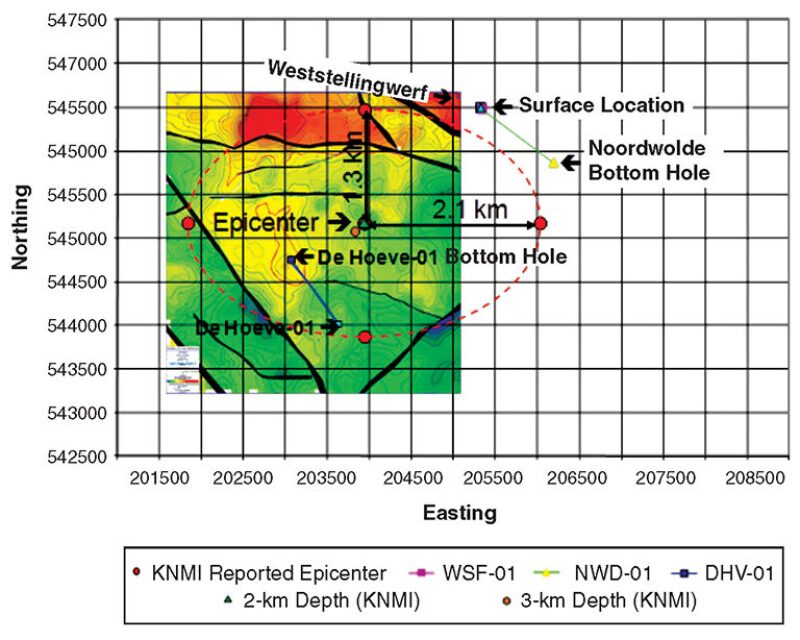
The tremor’s epicenter was identified by the KNMI (Koninklijk Nederlands Meteorologisch Instituut: Royal Netherlands Meteorological Institute) (Fig. 1). Three wells are located near the epicenter: Weststellingwerf-01 (WSF-01), Noordwolde-01 (NWD-01), and De Hoeve-01 (DHV-01). They all are producing from formations at a depth of approximately 2 km.
- Well WSF-01 was a gas producer between 1998 and 2004; -cold‑water injection started in 2008 with no tremor reported during the gas-production phase.
- Well NWD-01 is immediately outside of the epicenter perimeter. It was producing gas at the time of the event, with no tremor measured before November 2009 and none after.
- Well DHV-01 is located in the middle of the estimated epicenter area, but had not been drilled at the time of the event.
The observed tremor, because of its shallow depth, was assumed to be induced instead of having occurred naturally. It was attributed by KNMI to displacements along the Weststellingwerf fault because the seismograms were in agreement with a normal west/east-striking fault. It was thus necessary to identify which mechanism was at the origin of the fault movement, to investigate whether an earthquake could occur in the future, and to determine the magnitude of the event.
Five mechanisms were studied:
- Salt dissolution
- Reservoir depletion during gas production
- Reservoir repressurization caused by water injection
- Temperature variations caused by cold-water injection
- Fault weakening caused by lubrication or annihilation of capillary pressure during water injection
However, salt dissolution during water injection was quickly discarded as being at the origin of the tremor because the reservoir intervals do not contain halite. Carbonate dissolution was not pronounced and could not explain fault weakening caused by water injection, either.
The workflow included seismic interpretation and geological and dynamic modeling before geomechanical modeling.
Geological Modeling
A summary of the sedimentation phases and tectonic events that affected the area provided the geological framework for seismic interpretation and geological modeling.
From a structural point of view, the area of interest is located on the Friesland platform and is bordered on the southwest by the Texel-Ijsselmeer high, on the northwest by the Vlieland basin, and on the east by the Lauwerszee trough and the Lower Saxony basin.
Data from five wells were used: WSF-01, NWD-01, Vledder-01 (VLR-01), Nieuwehorne-01 (NWH-01), and DHV-01. Well logs included gamma ray and sonic for all wells, and density for WSF-01, NWH-01, and DHV-01, as well as petrophysical logs (e.g., water saturation, total porosity, and effective porosity) for all wells. Several faults were interpreted on the 3D-seismic survey. Because of the deterioration of the seismic signal in the deeper parts, it was difficult to determine how deep the faults extended. The five wells, present in the area of interest, were correlated to provide the framework for building the static geological model. This model includes the stratigraphical units from the Limburg group to the Texel formation. The base of the model is set to 100 m below the top of the Limburg group. The top of the model is set to 75 m above the top of the Vlieland claystone formation. The depth-converted surfaces and faults were used as the main input for the construction of the geological model. Isochore maps derived from the formation thicknesses at the well locations were used to build additional subdivisions of the model.
Structural and petrophysical models were also built. Structural models helped create the zones and to choose layering. A petrophysical evaluation was performed to estimate the initial porosity, permeability, gas volume, and water saturation of the reservoirs.
The reservoir of interest is the Z2 carbonate member, which is part of the Permian Zechstein group. It is generally described as brown-beige compact limestone and dolomite. The initial pressure and temperature of the reservoir were, respectively, approximately 22.16 MPa and 77.2°C at a depth of 1927 m. The gross and net thicknesses of the reservoir are, respectively, 24 and 13.4 m, with an average porosity of approximately 7% and an average gas saturation of 88%. The permeability of the formation is approximately 9.5 md.
For a discussion of reservoir modeling in this study, please see the complete paper.
Geomechanical Modeling
The 2D geomechanical model has been built according to a north/south cross section perpendicular to the Weststellingwerf fault. The objectives of the geomechanical simulation were to evaluate the stress variations that occur along the Weststellingwerf fault during depletion and water-injection phases. As a consequence, the computations were performed according to the effective-stress notion of poromechanics with an initial state of stress equal to zero in order to obtain these variations directly.
Faults were simulated assuming that pore pressures within the faults remained constant with time, which is a pessimistic hypothesis regarding the risk of fault slippage.
Because the stiffness of Z2 carbonate formation is a function of porosity, the reservoir layer between two central faults was divided into three different groups of porosity (0–4, 4–8, and 8–14%), the grid being very refined in these zones. The grid was extended leftward, rightward, and downward to eliminate effects of boundary conditions on the results. The horizontal displacement at lateral sides of the model and the vertical displacement of the basis of the model are prevented.
The main conclusions from the geomechanical simulations include the following:
- The decrease in pore pressure during depletion induces a decrease in stress normal to the fault, thereby promoting fault reactivation. However, no earthquake was detected during reservoir production.
- The increase in pore pressure during water injection generates an increase in stress normal to the fault in the reservoir because of the expansion of reservoir, which prevents fault reactivation. If it also could increase pore pressure in the section of the fault located in the overburden, it could induce a decrease in effective stress normal to the fault and then promote fault sliding. However, the simulations showed that the increase in pore pressures was so low that the pore pressure never returned to the initial pore pressures before gas production. Consequently, this mechanism cannot be used to explain the De Hoeve tremor.
- The decrease in temperature induces a decrease in normal stresses that could promote fault reactivation. However, the simulations showed that the induced stress variations at the fault location were so low that this mechanism cannot be used to explain the De Hoeve tremor.
- The variations in shear and normal stresses during short-term water injection are negligible compared with the stress variations occurring during depletion: Pressure depletion is more critical to sliding than the combination of repressurization and cooling. Consequently, short-term injection could have triggered sliding of the fault only if the fault was already at the onset of sliding or if the cohesion or friction angle of the fault has been reduced because of water injection. This result led to consideration of a main scenario of fault weakening during water injection.
- Computed stresses along the Weststellingwerf fault during long-term water injection show that the variations in shear and normal stresses caused by cooling during long-term water injection are negligible compared with the variations that occurred during depletion. Consequently, stress variations during long-term injection cannot trigger sliding of the fault.
Discussion
Aside from the salt-dissolution mechanism, three other mechanisms have been analyzed to explain fault sliding.
- Reservoir depletion: According to this scenario, reservoir depletion induces a decrease in normal effective stress along the section of the fault located in front of the reservoir and an increase in shear stress. However, this means that an earthquake would have been recorded during depletion, which was not the case.
- Reservoir repressurization to a value lower than the initial state: According to this scenario, the normal effective stress immediately above the reservoir would have been decreased because of fluid diffusion along the fault. However, this requires that fluid pressure be increased at the fault location, which did not occur.
- Reservoir cooling: According to this scenario, reservoir cooling induces a decrease in normal effective stress along the section of the fault located in front of the reservoir and an increase in shear stress. However, simulations showed that stress variations caused by cooling are lower than stress variations caused by repressurization.
Because no seismic event was observed during depletion and pore pressure and temperature variations were very low during injection at the time of the earthquake, another triggering mechanism had to be found. After reviewing all available analyzed data, it was decided that the best explanation would be that water, when first contacting the fault, reduced the resistance of the fault gouge by lubrication or annihilation of capillary pressures. If capillary pressure is an important contributor to gouge cohesion, as in some chalk, silt, and calcarenite formations, waterflooding would decrease gouge cohesion, thereby easing fault sliding. The model of annihilation of capillary pressures assumes that, initially, the fault is full of a gas-saturated gouge made of calcite (or other) grains with no other cohesion than from capillary pressures, and that capillary pressures are annealed when first contacted by water.
On the basis of this mechanism of fault failure, it seems reasonable to postulate that the section of the fault that moved during the tremor will not exhibit further movement because there will not be sufficient stress variations along the fault to induce further fault displacement, and weakening of the fault gouge has already occurred. The only sections that may slide in the future are sections that have not yet been in contact with water. However, for reasons explained in the complete paper, the magnitude of future induced tremors should be lower than that of the November 2009 tremor.
Considering that fault weakening could have caused the Weststellingwerf fault to slip, it is anticipated that, at the location where fault displacement occurred, most of the shear stresses have been released during the earthquake that took place in November 2009 and that no further fault weakening should occur because it already occurred when water first contacted the fault. Therefore, this section of the fault should not exhibit further sliding.
However, local fault sliding may have increased shear stresses on both sides of the section where fault displacement occurred. These sides have not been contacted by water at present, but may be contacted by water during continued water injection. On the basis of the mechanism that is assumed to be at the origin of the Weststellingwerf fault slip, it seems that water injection could cause new Earth movements in the future. Fortunately, as mentioned previously, the magnitude of these should be lower than the magnitude of the November 2009 tremor.
This article, written by JPT Technology Editor Chris Carpenter, contains highlights of paper SPE 166430, “Inducing Earthquake by Injecting Water in a Gas Field: Water-Weakening Effect,” by Axel-Pierre Bois and Mehrdokht Mohajerani, CurisTec; Niek Dousi, SGS-Horizon; and Stijn Harms, Vermilion Energy, prepared for the 2013 SPE Annual Technical Conference and Exhibition, New Orleans, 30 September–2 October. The paper has not been peer reviewed.